Home Multi-Country Search About Admin Login
Cenozoic
Cretaceous
Jurassic
Triassic
Permian
Carboniferous
Devonian
Early Paleozoic

Search by
Select Region(s) to search
Hold Ctrl (Windows/Linux) or Command (Mac) to select multiple
Nong Pong Formation
Click to display on map of the Ancient World at:
Nong Pong Fm base reconstruction

Nong Pong Fm


Period: 
Permian

Age Interval: 
Early–Middle Permian (13)


Province: 
Indochina Block: Loei Fold Belt

Type Locality and Naming

Khao Kwang Platform (Saraburi region): East of Khao Khwang, grid ref. 560 to 600 E and 440 to 470 N sheet 47P/FG 22, Series L 7017 by Hinthong and others (1985). Parent unit: Saraburi Gr.

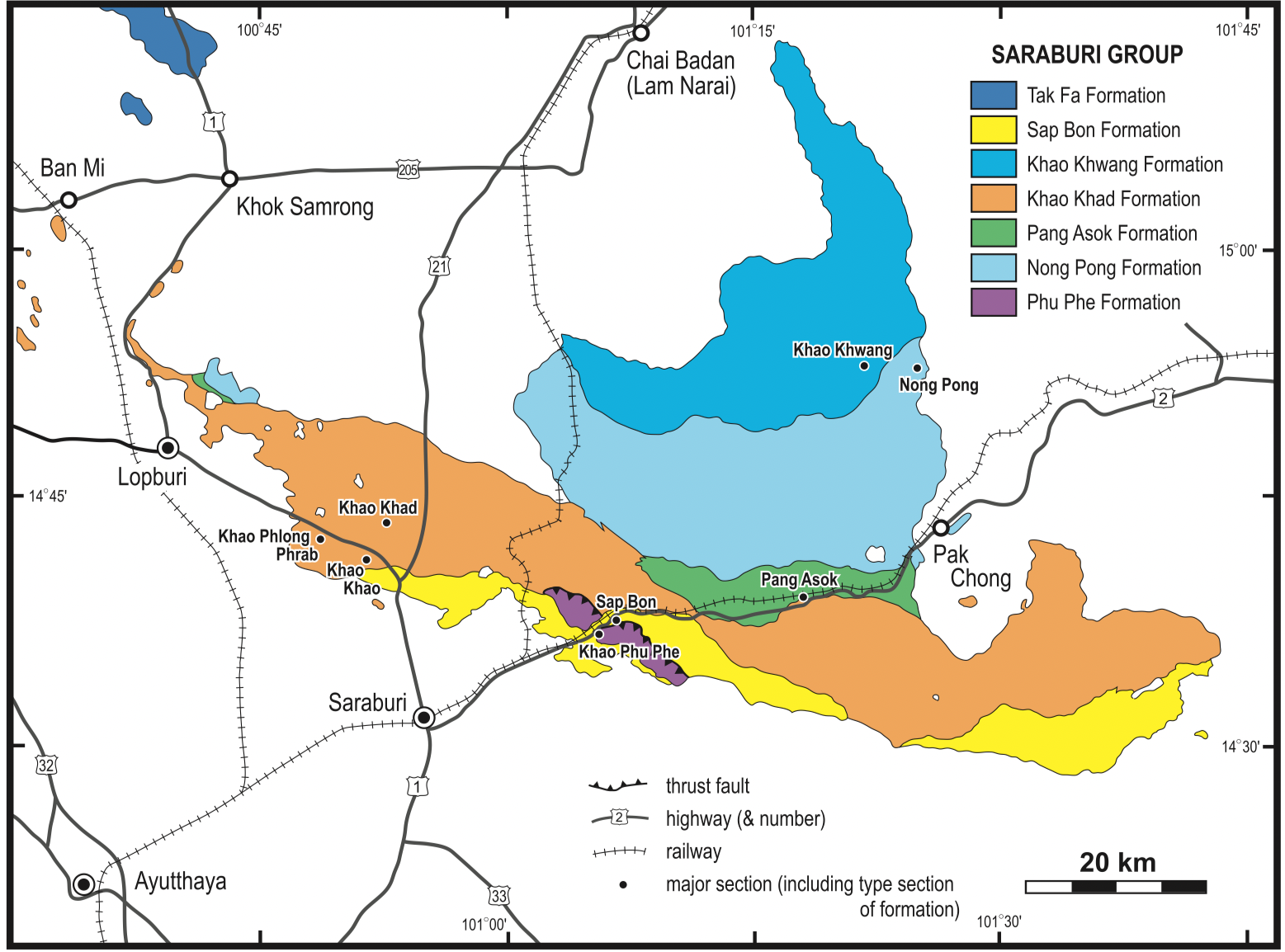
[Figure: Geological map of Saraburi Group in Saraburi area, NE Thailand (Ueno and Charoentitirat, 2011).]

Synonym: หมวดหินหนองโป่ง


Lithology and Thickness

Grey to greenish-grey, banded limestone, dark grey to greyish-brown shale, grey to very dark grey, thin- to thick-bedded limestone, interbedded with brownish-grey shale; in Middle part, grey to brown shale interbedded with grey to dark grey limestone grading upward to well bedded, grey limestone and in Upper part, grey to brownish-grey shale intercalated grey to dark grey limestone lens. Thickness: 673 m

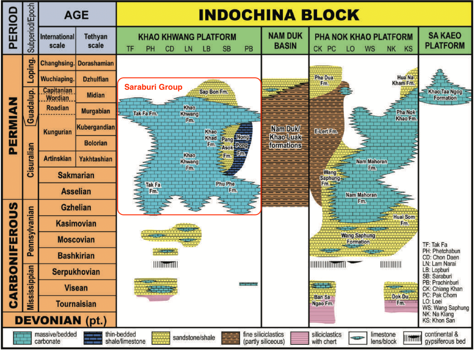
[Figure: Carboniferous and Permian facies distribution and resultant stratigraphic subdivisions on the western margin of the Indochina Block, with Saraburi Group highlighted (Ueno and Charoentitirat, 2011).]


Lithology Pattern: 
Pelagic marl


Relationships and Distribution

Lower contact

not mentioned

Upper contact

not mentioned

Regional extent

in the Saraburi area of Loei-Phetchabun Ranges and northwest of the Khorat Plateau.

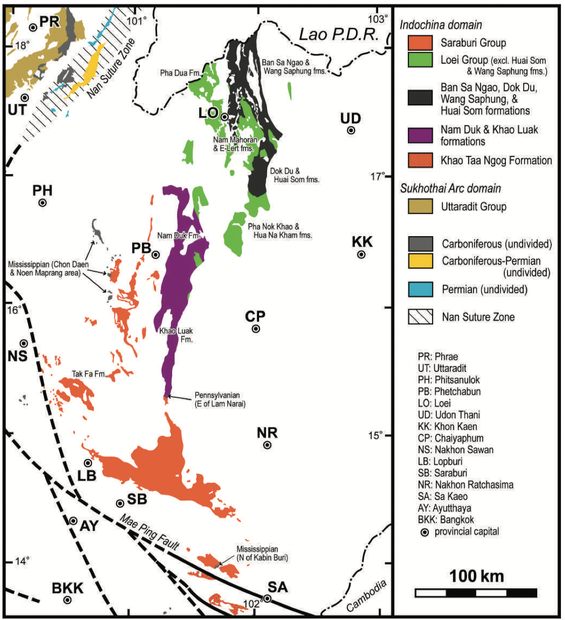
[Figure: Distribution of Carboniferous and Permian in NE Thailand. Data mainly based on 1:1 million scale geological map of Thailand (DMR 1999) with minor modifications (Ueno and Charoentitirat 2011).]


GeoJSON

{"type":"Feature","geometry":{"type":"MultiPolygon","coordinates":[[[[101.25,17.53],[101.29,17.56],[101.33,17.51],[101.34,17.39],[101.53,16.88],[101.65,16.51],[101.62,16.36],[101.54,16.03],[101.47,15.59],[101.46,15.15],[101.48,14.96],[101.41,15.06],[101.36,15.2],[101.29,15.35],[101.2,15.51],[101.17,15.68],[101.1,15.94],[101.12,16.18],[101.15,16.37],[101.21,16.58],[101.23,16.82],[101.25,17.04],[101.25,17.27],[101.25,17.53]]]]}}

Fossils

Hinthong (1981) mentioned the occurrence of Agathiceras and fusulines of probable late Early–early Middle Permian (Yakhtashian–Kubergandian) age (Assavapatchara et al. 2006), although details of these occurrences have not been reported (Ueno and Charoentitirat, 2011).


Age 

Lower Permian (Artinskian-Kungurian) (Lexicon of Stratigraphic Names of Thailand, 2013); Early–Middle Permian (The Geology of Thailand, 2011)

Age Span: 

    Beginning stage: 
Artinskian

    Fraction up in beginning stage: 
0

    Beginning date (Ma): 
290.06

    Ending stage: 
Roadian

    Fraction up in the ending stage: 
0

    Ending date (Ma):  
272.30

Depositional setting

Basinal setting

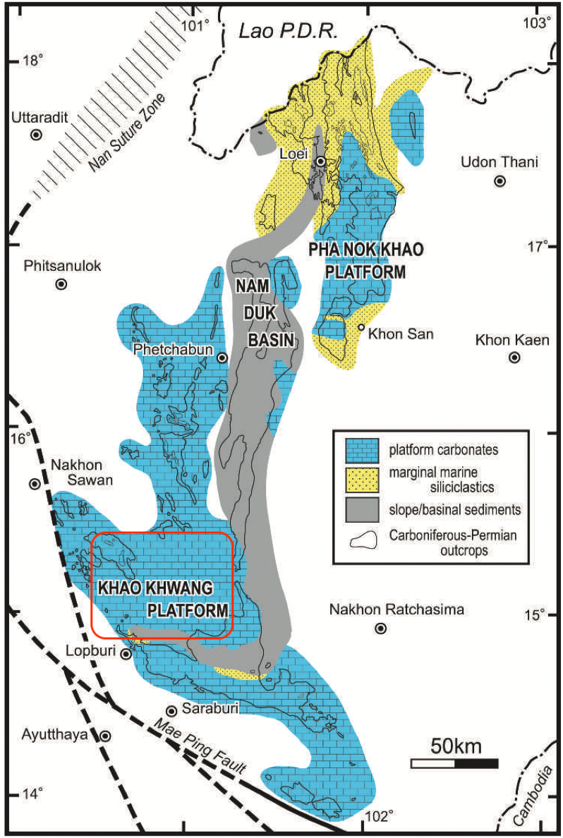
[Figure: Late Paleozoic major facies subdivisions on the western margin of the Indochina Block by Ueno and Charoentitirat (2011). (Slightly modified from Wielchowsky & Young 1985).]


Depositional pattern:  


Additional Information

Remarks: This formation was previously mapped as part of the Ratburi Group (Hinthong and others, 1985).

Pendexter (1980) studied the sedimentary facies and depositional environment and suggested that it was deposited in a basinal setting. The available sedimentological and age data suggest that it could be the basinal time-equivalent of the Phu Phe, Khao Khad and Khao Khwang shallow-marine platform-facies formations. This slightly deeper area of the Khao Khwang Platform may be the continuation of the Nam Duk Basin (Ueno and Charoentitirat, 2011).


Compiler:  

Wen Du -modified from Ueno K. & Charoentitirat T., 2011, Chapter 5 Carboniferous and Permian in Ridd, M.F., Barber, A.J., and Grow, M.J., editors, The Geology of Thailand, Geol. Soc. of London. And Lexicon of Stratigraphic Names of Thailand of 2013